
Forget about trial and error.
Hands-on Training
With over 1,000,000 hectares flown our team has flown everywhere, man. Whether you are flying in a complex environment or bringing a new sensor into the field, we can make sure everything goes right, the first time.
Enjoy the ease of learning from a professional
Fly with confidence
Learn about flying in complex environments. Whether it is near an international airport, over a wildfire, or just your first time with a drone.
Become familiar flying in:
Controlled airspace
Dense urban areas
Industrial environments
Remote settings
What is hands on training?
FlySmart hands-on drone training teaches drone pilots how to operate, maintain, and troubleshoot their equipment through practical learning. It includes flying drones, practicing maneuvers, and understanding safety regulatory guidelines, offering experiential education rather than just theory.
Participants learn how to control drones effectively, including takeoff, landing, hovering, and executing different flight maneuvers.
Flight Skills:
Understanding safety guidelines and protocols is crucial to prevent accidents and ensure responsible drone operation.
Safety Procedures:
Participants learn how to inspect, maintain, and repair drones, including basic troubleshooting techniques for common issues.
Maintenance and Repair:
Participants learn how to control drones effectively, including takeoff, landing, hovering, and executing different flight maneuvers.
Regulatory Compliance:
Applications and Use Cases:
Hands-on training may also cover various applications of drones across industries such as aerial photography and videography, agriculture, surveying, mapping, and search and rescue operations.
FlySmart Hands-On Drone Training Programs
Ready to help at any stage of your operation.
Mission Planning
UgCS
Nav Drone
Google earth Pro
DJI Pilot 2
Learn effective and efficient mission planning with:


Agricultural
FlySmart instructors are DJI Agras certified.
Agricultural spraying and spreading drones are rapidly being introduced across Canada. Our team can help understand:
Setting up your aircraft
Mission planning
Safe operations
Efficiency

Infrared Payloads
Wildfire operations or solar panel inspections.
Get your questions answered.
Efficient data collection
Camera setup
Effective mission parameters
Data interpretation guidance

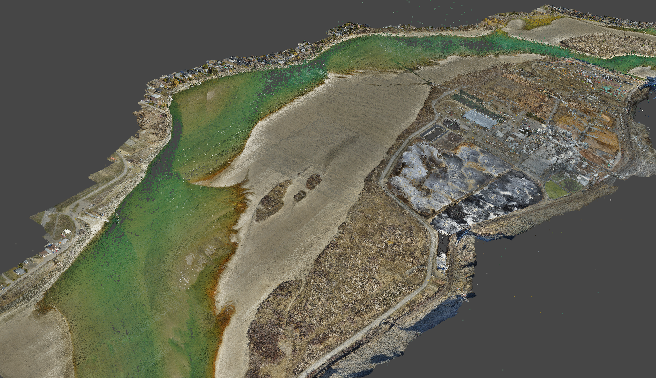
LiDAR Payloads
Collect, process, and deliver confidently.
Collection
Data collection best practices
Ground control guidance
Equipment setup checklist
Processing
Industry product standards
Point cloud classification
DEM, DSM, and point clouds
Data Processing
Wildfire operations, RTK Mapping or LiDAR. Let us show you how.
Nova - Agisoft Metashape - Pix4D
Data interpretation
Using ground control points
Raw data to final product guidance
Data issues troubleshooting


