How Drones Are Helping Our Environment
Did you know that even a small increase in body temperature by just 2°C can make us feel slightly feverish? It's the same with the environment! Humans have been emitting a lot of greenhouse gases since industrializing, which has caused the earth's atmosphere to warm up. This has led to all sorts of extreme weather events like droughts, rising sea levels, and loss of biodiversity.

But there are things we can do to help! We can switch to renewable energies, promote alternative forms of travel, and even use drone technologies to protect the environment in the long term. Let's dive into how drones can help save the planet!
1. Wildlife Protection and Monitoring
Drones are being used to help protect wildlife in a number of ways. One of the most common applications is for monitoring and tracking endangered species. Drones equipped with cameras can fly over remote areas and capture images and videos of animals that might otherwise be difficult or dangerous to approach. The data collected includes population surveys, and wildlife behaviour that can then be used to help scientists better understand the behaviour and habitat of these animals, and to identify areas that need protection.

In addition, drones are also being used to monitor and map wildlife habitats, including forests, wetlands, and marine environments. This data can help researchers better understand the health and diversity of ecosystems and identify sensitive areas.
Drones are also being used to combat illegal poaching. Rhino and elephant poaching are major issues in many parts of the world, and drones are proving to be a valuable tool in the fight against this activity. Equipped with thermal imaging cameras, drones can detect the heat signature of poachers and alert rangers to their presence. This allows for a rapid response, increasing the chances of catching the poachers in the act and preventing further harm to the animals.
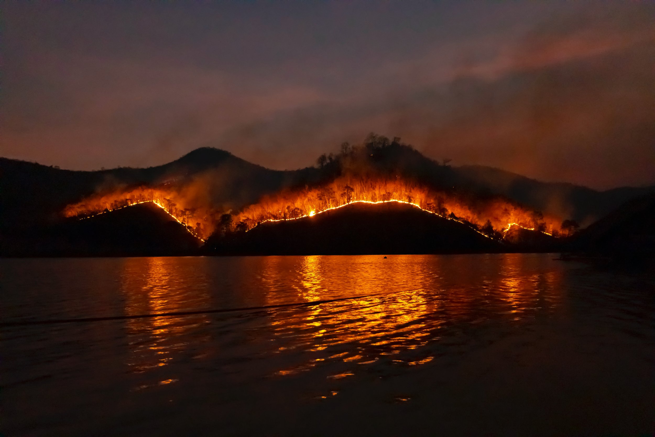
2. Wildfire Fighting
Drones have become an increasingly valuable tool for firefighters in the battle against wildfires. One of the ways in which drones are used is through heat mapping and scanning. Heat mapping and scanning involves using infrared cameras mounted on drones to capture images of the wildfire area. These images are then used to create a georeferenced map of the fire that shows the areas of greatest heat intensity. This information can be used by firefighters to identify the location of the fire's perimeter, hotspots, and areas where the fire is spreading most rapidly.
Heat mapping and scanning using drones offer several environmental benefits. Drones allow firefighters to monitor the spread of the fire and its impact on vegetation, wildlife, and water sources, which can help them make informed decisions that minimize environmental damage. This technology also allows firefighters to quickly identify the areas where the fire is most intense, which helps them prioritize their efforts and reduce the overall damage caused by the fire. To contain the spread of fires more quickly, early detection is necessary.
Forest and bush fires are part of a natural cycle of the ecosystem. However, what is of concern here is the extent and increasing frequency of its occurrence. Climate change is leading to extreme weather fluctuations with long periods of drought, which encourage forest and bush fires.
Curious to see how infrared sensors, drones, firefighters and AI technology can come together to fight wildfires? Download a sample data package from fireai.io and create a map from infrared images captured by drone of a wildfire. These smart maps are being used by firefighters to detect dangerous “hotspots”, which will help them take down fires more safely and effectively.
3. Sustainable Agriculture and Crop Monitoring
According to market research, Agricultural drone sales should be increasing massively in the next couple of years. Agricultural drones alone are predicted to generate sales of 5 billion dollars by 2024. But why are they becoming so popular?
Agricultural drones can help give an accurate picture of the health of crops and soil. These drones can cover several hectares of land in just a few minutes, which saves a lot of time and effort. By analyzing soil quality, moisture levels, and other factors, farmers can tell whether the crops need more water or fertilizer, and they can also estimate when they will be ready for harvesting. Drones can also help identify and monitor pest and disease outbreaks, enabling targeted interventions rather than widespread pesticide use. This can reduce the impact on beneficial insects and decrease pesticide use while maintaining crop health.
Once the drone has collected all the data, it is converted into digital maps that can be used to calculate the exact amount of fertilizer, water, and pesticides needed. Over-application of these resources can lead to runoff into nearby bodies of water or seep into the soil, causing pollution. Through this optimizing of resource usage and improving overall farming efficiency, drones can help reduce the carbon footprint of agriculture.
4. Transportation and Delivery
According to this article from the Smithsonian, drones have been found to be up to 54% more efficient than traditional delivery trucks in certain states when it comes to package delivery. This higher efficiency can play a significant role in reducing CO2 emissions associated with deliveries, making drones an eco-friendly option for parcel delivery in areas where conditions are favorable. As lightweight packages can be easily picked up and transported to their destination, traffic congestion in city centers can be reduced. Additionally, drone delivery ensures climate-friendly logistics such as reducing CO2 emissions, can start to be implemented within urban areas. As a result, it is expected that drones will significantly transform how we transport goods, with their use as postal and parcel carriers becoming more commonplace in the future.
5. Reforestation Efforts
Mast Reforestation (previously Droneseed) is a company that is changing the face of reforestation efforts with its innovative use of drone technology. The company's fleet of drones has been instrumental in planting tree seeds in areas that have been ravaged by wildfires, deforestation, and other natural disasters. This approach has proven to be much faster, more efficient, and more cost-effective than traditional methods of planting trees.
The process of reforestation through the use of drones involves several steps. First, they use specialized drones equipped with advanced sensors and software to map out the planting area. This allows the drones to determine the best locations to plant the tree seeds. Once the mapping is complete, the drones fly over the area and drop the seeds with incredible accuracy. The drones can plant up to 800 seeds per hour, which is much faster than manual planting methods.
Overall, reforestation efforts are a game-changer in the fight against deforestation and climate change. The use of drone technology makes the process faster, more efficient, and more effective, allowing for the regeneration of forests on a scale that was previously impossible. This has the potential to make a significant positive impact on the environment, and is a step towards a more sustainable future.
These are just a few of the ways drones are positively impacting the environment! They are becoming more and more of an important tool in environmental conservation and sustainability, and will continue to make a positive impact as technologies advance!
Happy (and safe) flying!
- FlySmart Team